


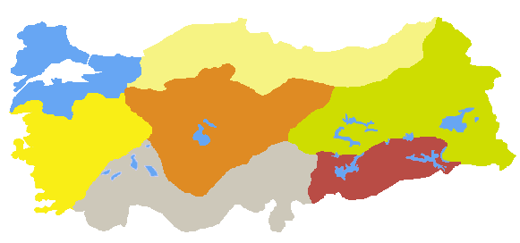
Turkey was divided into 7 main geographical regions and 21 geographical sub-regions at the First Turkish Geographical Congress held from June 6-21, 1941: Mediterranean Region, Eastern Anatolia Region, Aegean Region, Southeastern Anatolia Region, Central Anatolia Region, Black Sea Region, and Marmara Region. Location: Classified as a Balkan, Mediterranean, Caucasus, and Middle Eastern country, the Republic of Turkey is situated in a transition zone between Eastern and Western cultures. The part located in what was formerly known as Asia Minor is now called Western Anatolia. The region in the Balkan Peninsula (Southeast Europe) is called Thrace, and the region east of the Taurus Mountains, including ancient Persia and Northern Mesopotamia, is called Eastern Anatolia. The Anatolian peninsula is surrounded by the Black Sea, the Sea of Marmara, the Aegean Sea, and the Mediterranean Sea. Turkey's neighbors are Bulgaria and Greece to the west, Georgia, Armenia, Azerbaijan, and Iran to the east, and Iraq and Syria to the south. Historically, Turkey is located in one of the richest regions in the world. The word Anatolia originates from the Greek word Anatolia, meaning "east" or "sunrise," and does not appear as a regional name in historical documents. The ancient names of the provinces of Western Anatolia were: Bithynia, Paphlagonia, Ionia, Cappadocia, Mysia, Cilicia, Lycia, Caria, Pisidia, Pamphylia, Lydia, and Phrygia. In antiquity, the Romans also called Western Anatolia the "province of Asia," and its capital was ancient Ephesus, one of the largest Roman cities. The regions we now call Eastern Anatolia, east of Cappadocia and the Taurus Mountains, represent ancient Mesopotamian and Persian cultures. The Taurus Mountains and the Euphrates River are considered by historians as the boundary between Western and Eastern cultures. In antiquity and the Middle Ages, the region east of Cappadocia and the Taurus Mountains was generally referred to by names such as Mesopotamia, the Persian Empire, Urartu, Armenia, Commagene, Syria, and Pontus. The Taurus Mountains have always been a natural border, a difficult passage between Roman and Persian armies, and between Eastern and Western armies. Throughout history, many tribes and cultures have settled in what is now Turkey, coming from both East and West. Examples of tribes and cultures that have settled in Turkey throughout history include, from the East: the Hittites, Assyrians, Urartians, Persians, Seljuks (and long before the Seljuks: the Scythians, Huns, Khazars, Pechenegs, Kipchaks), Arabs, Christianity, Islam, and Judaism; and from the West: the Romans, Greeks, and peoples from Southeastern Europe (Balkan), ancient polytheistic Greek-Roman cultures, etc. Turkish lands are described by historians and archaeologists as an "open-air museum." Its 8,000 km coastline is filled with remnants of ancient Roman and Greek cultures. It is stated that the name "Turkey" was first given to this geography by the Holy Roman Emperor Frederick Barbarossa (1123-1190). In official records, it appears in 19th-century British correspondence. The Republic of Turkey is the heir to Central Asian Turkic culture, as well as Roman, Persian, Mesopotamian, Byzantine/Eastern Roman, Ottoman, and other cultures. Natural structure: More than half of the country consists of high-altitude areas exceeding 1,000 meters. Approximately one-third is covered by medium-altitude plains, plateaus, and mountains, and 10% by lowlands. The highest and most mountainous areas are located in the eastern part. The northern part is characterized by the Northern Anatolian Mountains, while the southern, eastern, and southeastern parts are characterized by the Taurus Mountains. The highest point in the country is the summit of Mount Ararat, reaching 5,166 meters. The main large plains are the Çukurova, Konya Plain, and Harran Plain. The longest river whose source and mouth are within the country's borders is the Kızılırmak, which is 1,355 kilometers long. The largest natural lake is Lake Van, covering an area of 3,713 km². The Atatürk Dam Lake, covering an area of 817 km², is the country's largest artificial lake. Gökçeada, the largest island in Turkey, has a surface area of 279 km². Atatürk Dam Lake is the country's largest artificial lake. Gökçeada, Turkey's largest island, has an area of 279 km². Mountains: Mount Ararat - 5,137 m, Mount Cilo (Buzul) - 4,116 m, Mount Cudi - 5,000 m, Mount Süphan - 4,058 m, Mount Kaçkar - 3,932 m, Mount Erciyes - 3,917 m, Mount Uludağ - 2,543 m. Rivers of Turkey: Kızılırmak 1,355 km², Yeşilırmak, Euphrates, Sakarya, Murat, Tigris, Seyhan River, Ceyhan River, Göksu, Çoruh, Büyük Menderes. Basins of Turkey: Natural Lakes: Lake Van 3,713 km², Lake Tuz 1,500 km², Lake Beyşehir 656 km², Lake Eğridir 468 km², Lake Akşehir 353 km², Lake İznik 298 km², Lake Burdur, Lake Salda, Lake Eymir. Islands: Gökçeada 279 km², Balıkesir; Marmara Island 117 km² Bozcaada 36 km², Uzunada 25 km², Balıkesir Alibey Island 23 km², Balıkesir Paşalimanı Island 21 km², Balıkesir Avşa Island 21 km². Climate: Turkey's location surrounded by seas on three sides, the position of mountains, and the diversity of landforms have led to the emergence of different climate types. Coastal regions experience milder climate characteristics due to the influence of the seas. The North Anatolian Mountains and the Taurus Mountains prevent the influence of the sea from penetrating inland. Therefore, continental climate characteristics are observed in the interior. Mediterranean climate: This climate type, effective on the coasts of the Mediterranean and Aegean Seas, extends to the southern coast of the Marmara Sea. The characteristics of this climate are seen up to approximately 800 meters in altitude from the coast. Its influence decreases as one moves inland. In this climate type, summers are hot and dry, and winters are mild and rainy. Annual rainfall is above 1,000 mm in some places, while it is less in most places. Frost and snowfall are rare, except in the high mountainous regions. The Black Sea climate is a type of climate found on the northern coasts of Turkey, on the slopes of mountains facing the sea. In this climate, summer temperatures are not as intense as in the Mediterranean climate. Winters are colder than on the southern coasts. Frost occurs occasionally, fog is seen, and snowfall is common. The most important characteristic of the Black Sea climate is that precipitation occurs in every season. Moist air coming from the Black Sea rises and condenses on the seaward slopes of the Northern Anatolian Mountains, bringing rainfall to the coasts even during the summer months. The Black Sea Region receives the most rainfall. In Rize and its surroundings, the annual rainfall reaches 2,500 mm. Continental climate: A continental climate is observed in parts of Turkey that are far from the sea and do not benefit sufficiently from the influence of the sea due to the obstacles created by the topography. Central Anatolia, Eastern Anatolia, and Southeastern Anatolia regions, as well as the inland areas of Thrace, are under the influence of a continental climate. In these areas, seasonal and daily temperature differences are large, and rainfall is generally low. Winters are long, cold, and snowy, while summers are short but hot. The most severe continental climate is seen in Eastern Anatolia. Due to its altitude, rainfall is higher than in Central Anatolia and Southeastern Anatolia. The wettest season in Central Anatolia is spring, while in Southeastern Anatolia it is winter. Central Anatolia receives the least rainfall. Although Southeastern Anatolia receives slightly more rainfall, it is under threat of drought due to high temperatures and evaporation rates. Although Turkey lies on the same parallels as, for example, Spain, the fact that the Anatolian Plateau, with an average altitude of over 1,000 meters, receives heavy snowfall and rainfall means that water shortages are relatively less pronounced. The Çukurova region, where agriculture has been practiced for 8,000 years, as well as the Aegean Region, Bafra, and Çarşamba plains, are considered among the most fertile lands in the world. Excluding tropical plants, 90% of the world's vegetable and fruit varieties are grown in Turkey. Even in antiquity, when Western and Northern Europe faced constant threats of famine and plague during the Middle Ages, the province of Asia Minor (present-day Aegean Region), the most fertile province of the Roman Empire, supplied Rome with grapes, wine, grain, olive oil, and various fruits and vegetables.